
 Print-Friendly Version
 Pour toutes informations en français, s'il vous plaît contactez Jenn ŕ francais@torontooutdoorclub.com.
Airport + Centennial Park along Etobicoke Creek 18k (12/27/2014)
PRE-REGISTRATION REQUIRED: Once you've reviewed the event details, and decided you'd like to join us, you MUST sign up at the bottom of this page.You are STRONGLY encouraged to read this page in its entirety before signing up. If you'd like to attend, we ask that you abide by our rules and procedures as a time/cost saving process (with an end result of keeping membership free and lower cost events).
| The Basics: |
| ||||||
| Event Type: | Hike | ||||||
| Event Location: | Burnhamthorpe Rd E & Mill Rd (North-West corner) | ||||||
| Date(s) & Time: | Sat, Dec 27 2014 10:00 AM | ||||||
| Registration Cut Off: | Fri, Dec 26 2014 8:00:00 PM | ||||||
| Event Duration: | 4.5 - 5 hours | ||||||
| Difficulty Rating: | D4: Moderate to Difficult | ||||||
| Event Coordinator(s): |
Arnie
You must be logged in to get the Event Coordinator contact information. | ||||||
| Member Cost: | Voluntary Donation Only (See Below) | ||||||
| Participant Info: | |||||||
| Who's Invited: | Members Only, 18 And Older Only | ||||||
| Maximum Group Size: | 15 | ||||||
| Minimum Group Size: | 3 | ||||||
| Number Registered So Far: | 15 (To see who's signed up, log in to the Member Area) | ||||||
| Are Dogs Permitted: | No | ||||||
| Itinerary: | |||||||
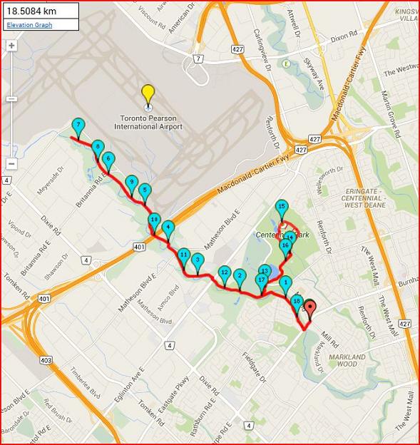
DISTANCE - 18.5km PACE - about 5.0 km/h DIFFICULTY - D4 Did you know that nearly one-third of Toronto
Pearson International Airport land is made up of
grasslands, farms and creek valley?
We will hike along the Etobicoke Creek Trail, which runs along the natural border between the cities of Toronto and Mississauga. When we get to the airport lands, it will be noisy!! You may want to bring ear plugs. (Most of the hike will not be noisy) This is the route we will take.
Don't get left behind! Please arrive early, we will start promptly, and I will turn off my cell once we begin hiking. For an interactive Route Map, of the map at the top of this page
| |||||||
| |||||||
| How to Get There: | |||||||
| Event Directions: | We will meet at the North-West corner of
Burnhamthorpe Rd E & Mill Rd (TTC and MiWay bus
stop is across the road). This place is
accessible via:
NOTE: The Bus ride from Islington to the meeting point takes around 20 min. So, plan to arrive at Islington at 9:00 am. PICTURE OF STARTING LOCATION
MAP OF BUS ROUTES AND STARTING LOCATION
| ||||||
| Notes: | |||||||
|
This hike will go forth rain or shine ☀ ☁ ☂ ☃
Although I am not crazy about hiking with lightning flashing all around me!
Don't get left behind! Please arrive early, we will start promptly, and I will turn off my cell once we begin hiking.
| |||||||
| Voluntary Donation: ( What is this?) Suggested donation amount for this event is: $2.00/Person. | |||||||
Cancellation/Partial Attendance: Please review our Cancellation Policy carefully! | |||||||