
 Print-Friendly Version
 Pour toutes informations en français, s'il vous plaît contactez Jenn ŕ francais@torontooutdoorclub.com.
Explore Obscure Don Valley Trails (15 KM) (1/22/2011)
PRE-REGISTRATION REQUIRED: Once you've reviewed the event details, and decided you'd like to join us, you MUST sign up at the bottom of this page.You are STRONGLY encouraged to read this page in its entirety before signing up. If you'd like to attend, we ask that you abide by our rules and procedures as a time/cost saving process (with an end result of keeping membership free and lower cost events).
| The Basics: |
| ||||||
| Event Type: | Urban Hike | ||||||
| Event Location: | Sherbourne Subway Station | ||||||
| Date(s) & Time: | Sat, Jan 22 2011 11:00 AM | ||||||
| Registration Cut Off: | Sat, Jan 22 2011 9:00:00 AM | ||||||
| Event Duration: | 3-4 Hours | ||||||
| Difficulty Rating: | D4: Moderate to Difficult | ||||||
| Event Coordinator(s): |
Fletcher
You must be logged in to get the Event Coordinator contact information. | ||||||
| Member Cost: | Voluntary Donation Only (See Below) | ||||||
| Participant Info: | |||||||
| Who's Invited: | Members Only, 18 And Older Only | ||||||
| Maximum Group Size: | 18 | ||||||
| Minimum Group Size: | 4 | ||||||
| Number Registered So Far: | 13 (To see who's signed up, log in to the Member Area) | ||||||
| Are Dogs Permitted: | No | ||||||
| Itinerary: | |||||||
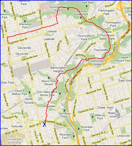
I've been wanting to run this hike for a really long time, but haven't had the right opportunity to do so. Till Now! We will be exploring some of the obscure trails in the Don Valley trail system. For example, Clothes Woods and the Don Valley Biking Trail. NOTE: We can only use the Don Valley Mountain Biking Trail in the winter, so this is the perfect time to explore this trail. We will follow this path:
Concluding this walk, anyone who wants to say, we can head to a local Tim Hortons to socialize. The hike is about 15 km overall and we will aim to hike at 3.5-4km/h. NOTE: This hike does not pass any subway stations other than at the beginning and end, so be prepared to walk all 15 KM as there will be few places to drop out of hike. Some walker/hikers like to go at a faster pace, but feel free to go at your own pace as the group meets together at major intersections or turns. | |||||||
| |||||||
| How to Get There: | |||||||
| Event Directions: | Sherbourne Subway Station is located on the Bloor Subway line, 1 stop east of Yonge/Bloor Station.
Map Picture | ||||||
| Notes: | |||||||
|
- We encourage all members to follow our Etiquette Guidelines at all times while participating in TOC events. - Details of this event are subject to undergo a change at any point in time, with or without warning. - Questions about equipment or rentals? Send them to safety@torontooutdoorclub.com. - Notice any errors or problems in the information on this page? Please notify our Content Editor(s), Stacy, at content@torontooutdoorclub.com. | |||||||
| Voluntary Donation: ( What is this?) Suggested donation amount for this event is: $1.00/Person. | |||||||
Cancellation/Partial Attendance: Please review our Cancellation Policy carefully! | |||||||