
 Print-Friendly Version
 Pour toutes informations en français, s'il vous plaît contactez Jenn ŕ francais@torontooutdoorclub.com.
Waterfront Trail #4 Whitby to Oshawa 31 to 36 km (11/22/2014)
PRE-REGISTRATION REQUIRED: Once you've reviewed the event details, and decided you'd like to join us, you MUST sign up at the bottom of this page.You are STRONGLY encouraged to read this page in its entirety before signing up. If you'd like to attend, we ask that you abide by our rules and procedures as a time/cost saving process (with an end result of keeping membership free and lower cost events).
| The Basics: |
| ||||||
| Event Type: | Hike | ||||||
| Event Location: | Oshawa Waterfront Trail, starting from the west side of Whitby Harbour, parking lot on Water St. | ||||||
| Date(s) & Time: | Sat, Nov 22 2014 9:00 AM (Carpool Departure: 8:20 AM *log in for location*) | ||||||
| Registration Cut Off: | Wed, Nov 19 2014 9:00:00 AM | ||||||
| Event Duration: | about 8 or 9 Hours (including driving to and from carpool) | ||||||
| Difficulty Rating: | D5: Difficult | ||||||
| Event Coordinator(s): |
Arnie
You must be logged in to get the Event Coordinator contact information. | ||||||
| Member Cost: | Voluntary Donation Only (See Below) | ||||||
| Participant Info: | |||||||
| Who's Invited: | Members Only, 18 And Older Only | ||||||
| Maximum Group Size: | 1 | ||||||
| Minimum Group Size: | 3 | ||||||
| Number Registered So Far: | 7 (To see who's signed up, log in to the Member Area) | ||||||
| Are Dogs Permitted: | No | ||||||
| Itinerary: | |||||||
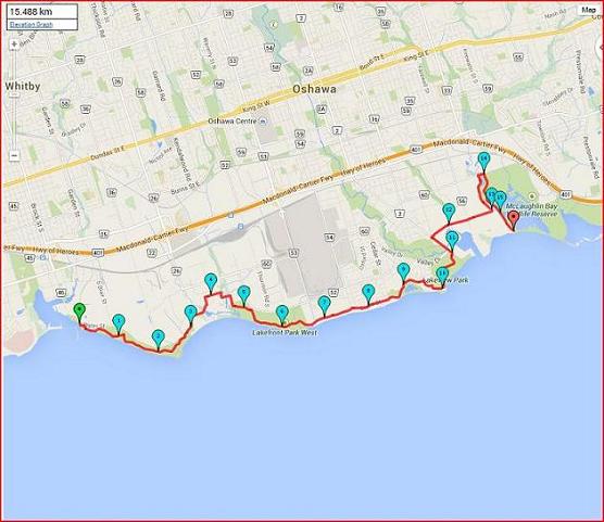
DISTANCE 31 to 36 km (YES 31 to 36)
PACE - pretty quick about 5.5+ km/h DIFFICULTY D5 (because of the distance and pace)
This event is restricted to experienced hikers who have D4 experience on hikes of at least 20 km. 36 (even 31) km is a considerable distance!!
FOURTH in a series of hikes that incorporate the Waterfront Trail, along a mainly paved path, but you could walk on the beach or grass along most of the way.
While checking out this area, I hiked the first 2 km along the beach instead of the paved trail.
Members willing to drive, will get first priority on the waiting list. Passengers
will be added as drivers become available.
DON'`T get left behind! Please arrive early, we will start promptly, and I will turn off my cell once we begin hiking. This is the route we will take.
For an interactive Route Map, of the map at the top of this page
DRIVERS: WHEN YOU SIGN UP, PLEASE ANSWER THE CARPOOL QUESTION REGARDING THE AMOUNT OF PASSENGERS YOU CAN TAKE IN YOUR CAR!!! | |||||||
| |||||||
| How to Get There: | |||||||
| Event Directions: | If carpooling: meet at 8:10 AM. Carpool departure is 8:20 AM
If meeting at event: meet at 8:55 AM. We start hiking at 9:00
MAP OF CARPOOL LOCATION
PICTURE OF CARPOOL LOCATION
MAP OF DRIVING FROM CARPOOL TO START OF HIKE
PICTURE OF STARTING LOCATION - PARKING LOT
| ||||||
| Carpool to Event Distance (round trip): | 76Km | ||||||
| Carpool Departure Time: | 8:20 AM | ||||||
| Carpool Location: | Log in for location | ||||||
| Carpool Directions: | Log in for directions | ||||||
| Carpool Cost: | Approximate vehicle expense for this event is $19.61 (calculated at total Km * $0.258, effective Thursday, May 2, 2024). This is based on $0.08/Km for maintenance, plus current gas price divide by 9. Your event coordinator will confirm exactly how much money is required from each person. | ||||||
| Notes: | |||||||
|
This hike will go forth rain or shine Don't get left behind! Please arrive early, we will start promptly, and I will turn off my cell once we begin hiking.
| |||||||
| Voluntary Donation: ( What is this?) Suggested donation amount for this event is: $2.00/Person. | |||||||
Cancellation/Partial Attendance: Please review our Cancellation Policy carefully! | |||||||