
 Print-Friendly Version
 Pour toutes informations en français, s'il vous plaît contactez Jenn ŕ francais@torontooutdoorclub.com.
Ultimate Urban Hike (24 KM) (10/31/2010)
PRE-REGISTRATION REQUIRED: Once you've reviewed the event details, and decided you'd like to join us, you MUST sign up at the bottom of this page.You are STRONGLY encouraged to read this page in its entirety before signing up. If you'd like to attend, we ask that you abide by our rules and procedures as a time/cost saving process (with an end result of keeping membership free and lower cost events).
| The Basics: |
| ||||||
| Event Type: | Urban Hike | ||||||
| Event Location: | Rosedale subway station | ||||||
| Date(s) & Time: | Sun, Oct 31 2010 11:00 AM | ||||||
| Registration Cut Off: | Sat, Oct 30 2010 11:55:00 PM | ||||||
| Event Duration: | 5-7 Hours | ||||||
| Difficulty Rating: | D4: Moderate to Difficult | ||||||
| Event Coordinator(s): |
Fletcher
You must be logged in to get the Event Coordinator contact information. | ||||||
| Member Cost: | Voluntary Donation Only (See Below) | ||||||
| Participant Info: | |||||||
| Who's Invited: | Members Only, 18 And Older Only | ||||||
| Maximum Group Size: | 20 | ||||||
| Minimum Group Size: | 6 | ||||||
| Number Registered So Far: | 19 (To see who's signed up, log in to the Member Area) | ||||||
| Are Dogs Permitted: | Yes | ||||||
| Itinerary: | |||||||
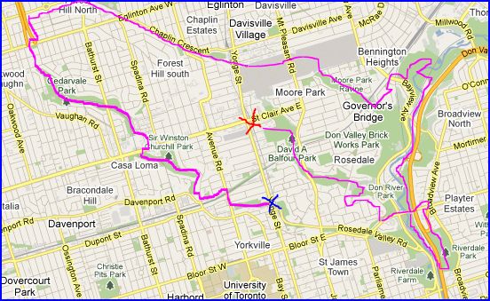
It's a hike to connect the city parks together
We'll stop for lunch during the hike, so pack a meal and plenty of water.
We will follow this path:
There are several points to drop off the hike, if you choose to do so.
| |||||||
| |||||||
| How to Get There: | |||||||
| Event Directions: | Rosedale Station is between Summerhill and is just one stop north of Bloor Station. Look for me at the entrance of the station, outside of the ticket booth. | ||||||
| Notes: | |||||||
|
There are several subway stations to drop off the hike including:
-Eglinton West Station -Davisville Station -Broadview Station -Castle Frank Station
| |||||||
| Voluntary Donation: ( What is this?) Suggested donation amount for this event is: $1.00/Person. | |||||||
Cancellation/Partial Attendance: Please review our Cancellation Policy carefully! | |||||||